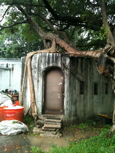
A Tree overgrows the back sheds of an old military complex in Wanhua 萬化的 Youth Park (青年公園), Taiwan. During the Japanese colonial era (1895-1945), the park along with neighboring Nanjichang Market (南機場), which means South Airport Market, was the site of Taipei's airport. I grabbed this shot last Friday night on my iPhone, on my way to said market.
6/18/2012
Subscribe to:
Post Comments (Atom)
Taiwan's Secret Pyramids
My friend Alain has a YouTube channel focusing on conspiracy theories, reptilians, UFOs, secret doors plus portals, sunken doors and so fort...

-
Banks in Taiwan generally refuse "foreigners" credit cards. I guess they're afraid they won't be able to recoup money (I w...
-
Here's the restroom in our commons' area. The sign reads: "Please don't use." Our cherished monkey bars We're fr...
-
My friend Alain has a YouTube channel focusing on conspiracy theories, reptilians, UFOs, secret doors plus portals, sunken doors and so fort...


4 comments:
The pic. reminds me anka wat cambodia.
ChoSan
That's what it reminded me of too: http://www.flickr.com/photos/patrick_cowsill/254248142/
So that was the civilian airport, before SongShan?
I've seen aerial photos of that airstrip at today's Youth Park, but I hadn't realized that there were still military structures left from that time. Were they built during the Japanese colonial period? Or did the ROC military use that strip, too?
"Were they built during the Japanese colonial period? Or did the ROC military use that strip, too?"
Yes, the Japanese built them. I think the ROC used them as well (for five years as Songshan didn't go into full use until 1950). There are some barracks in Youth Park; I guess the ROC had a lookout on the grounds. I took the shot out back of it.
Post a Comment